Birmingham Worcester Canal Section 1
Canals
Description
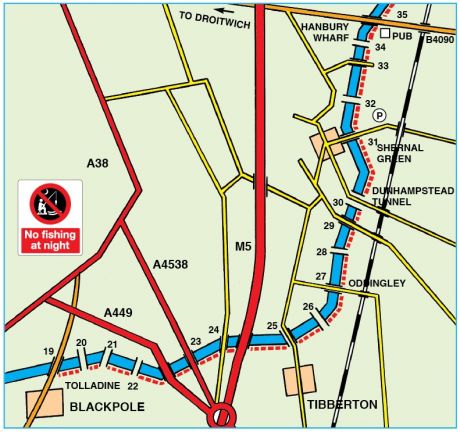
Bridge 19 Blackpole - Bridge 35 Hanbury WharfLocation (SATNAV)
Bridge 31
Lat 52°14'58.0"N Long 2°07'17.4"W (degs, mins, secs)
Lat 52.249431 Long -2.121514 (numerical)
Postcode WR9 7JS
Approaches
Birmingham Worcester Canal: All access to bridges - whether roads or tracks - are shown on the BAA map. Where no road or track leads to a bridge, the only approach to that area is via the towpath from the nearest access point.
Prohibition signs are mandatory. Anglers fishing near overhead power lines do so at their own risk.
NO FISHING AT NIGHT.
BAA Publication Map
Google Map

More locations on the canals
- Birmingham Worcester Canal Section 2
- Birmingham Worcester Canal Section 3
- Staffordshire & Worcestershire Canal Section 1
- Staffordshire & Worcestershire Canal Section 2
- Staffordshire & Worcestershire Canal Section 3
- Fazeley Canal Section 1
- Fazeley Canal Section 2
- Coventry Canal Fradley
- Trent & Mersey Canal Fradley
- Trent & Mersey Canal Alrewas
