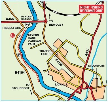
Ribbesford
Severn
Description
The river here starts to deepen and loses its' pace. Still plenty of barbel, plus bream, chub & roach, especially late in the season. Pike to 30lbs have been taken below the football pitch.Location (SATNAV)
Upstream lay-by
Lat 52°21'50.4"N Long 2°18'35.7"W (degs, mins, secs)
Lat 52.363998 Long -2.309922 (numerical)
Postcode DY12 2TQ
Outside Bewdley Town FC ground (do not block access)
Lat 52°21'26.8"N Long 2°18'53.4"W (degs, mins, secs)
Lat 52.357440 Long -2.314838 (numerical)
Postcode DY12 2TQ (nearby)
What3words charted.parsnip.broker
Approaches
Ribbesford: Cross the Severn at Bewdley, just past the church in the town centre turn left on to the B4194 (Stourport) Rd. Parking is alongside the fishery where the road runs along the river bank or in a car park just outside the Bewdley Town FC football pitch gates (do not block access) for access further downstream.
NIGHT FISHING BY PERMIT ONLY.
More locations on the Severn
- Aberbechan and Penarth
- Abermule
- Forden
- Buttington Bridge
- Pool Quay, Maesydd & Rhyddesgyn
- Underdale
- Apley Estate
- Knowle Sands
- Danery
- Eardington, Brook Section
- Quatford
- Hampton Loade Left Bank
- Hampton Loade 'B' Section
- Arley RB, LB, Harbour, Alveley, Stanley, Kinlet, Hextons Farm
- Trimpley, Northwood
- Blackstone
- Newhalls Meadow
- Ladyham
- Holt Fleet, Lock Island
- Grimley, Hallow
- Retreat Farm, Grimley
- Severn Stoke
- Bushley
- Ripple, Birds Meadow
- Deerhurst, Apperley
